OS Explorer
| OS Explorer | |||
 | |||
| |||
| Publisher: | Ordnance Survey | ||
| Scale: | 1:25,000 | ||
| First Published: | 1994 | ||
| Final Publication: | ongoing | ||
| SABRE Maps layer: | No | ||
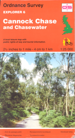
The Explorer range of OS maps were launched in 1994 to replace popular parts of the old Pathfinder Series. The initial range covered areas where the previous Pathfinders had sold particularly well, but were not covered by the existing Outdoor Leisure maps, and consisted of just five sheets. Following this original successful pilot, a further 26 sheets were produced in 1995.
After the success of the original Explorers, the decision was taken in 1996 to replace all Pathfinders with a comprehensive series of Explorers, covering the whole of Great Britain. Those sheets already created were integrated into the new series, albeit renumbered. The new series started with sheet 101 for the Scillys and took several years to work northwards until the northern Shetlands were completed.
One reason for the greater popularity of Explorers compared with Pathfinders is likely to be that each sheet covers a more useful area. Some sheets are printed on both sides and cover about 20 x 20 km per side; one-sided sheets cover about 20 x 30 km.
In 2002, the Ordnance Survey decided to integrate the Outdoor Leisure maps, which were also at 1:25,000 scale, into the Explorer series. The former Outdoor Leisure sheets kept their numbers although prefixed with OL. More recently, the number of maps in the Outdoor Leisure series has been increased, with a number of Scottish Explorers renumbered in the OL series, from OL46 to OL62. This has resulted in, for instance, the map covering Aviemore and the Cairngorms which started life as OL3, was later split into two and became Explorer 403 and 404 and is now numbered as OL57 and OL58.
SABRE Maps coverage
The Explorer range is still within copyright, and so cannot appear on SABRE Maps until the earliest sheets go out-of-copyright in 2045. Ordnance Survey do not license use of Explorer data to non-profit organisations, so current mapping cannot be shown, unlike the Landranger coverage.
Sheet Lists
| OS Explorer | ||||||||
| ||||||||
| ||||||||
|
