OS Quarter Inch
| Quarter Inch | |||
 | |||
| |||
| Publisher: | Ordnance Survey | ||
| Scale: | 1:253,440 and 1:250,000 | ||
| First Published: | 1902 | ||
| Final Publication: | 1978 | ||
| SABRE Maps layer: | Yes | ||
The OS Quarter Inch maps series was a range of maps initially at a quarter inch to a mile scale (1:253,440) but metricised to 1:250,000 scale in 1957.
Third Edition

Coverage of this mapping is available on SABRE Maps
The Third Edition was introduced in 1919, with a major revision to the mapping standards in 1926. The later revisions are often known as "A" or "New" Series, due to the fact that the layout many of the sheets covering England and Wales were changed, with the new sheets being given a sheet number suffixed with an "A", and Sheet 5 was withdrawn altogether as its area was covered by other sheets. Note that despite the colloquallism of "A" series, not all original sheets were moved - all Scottish sheets were issued on the same sheetlines throughout the edition's lifetime as were some England and Wales sheets, for example, Sheets 10 and 11.
These sheets pre-date the National Grid, or even the pre-war National Yard Grid; and so are based upon the Cassini (Delamere) projection.
The "A" or "New" Series was was the first "standard" series of the Ordnance Survey (beyond the MoT and Ten Mile Road Maps) to include road numbers on the mapping. To this end, later Third Edition mapping is extremely useful to have available on SABRE Maps.
Sheetlines
As the Quarter Inch Third Edition pre-dates any form of National Grid, each sheet does not have co-ordinates printed on them, but simply an alphanumeric grid with letters on the vertical axis and numbers across the top. However, as the sheets were built on the Cassini (Delamere) projection, it is possible to calculate the locations of each side of every sheet as a distance from the origin.
Knowing the locations of the corners of each sheet, whilst interesting in its own right, is essential to georeference each map and allow them to appear on SABRE Maps.
The below tables have therefore been produced so that the relevant values for the map series can simply be referenced for these purposes rather than having to calculate via the SABRE Maps Co-ordinate Finder.
In these tables, the values of each corner location are in miles from the origin point at Delamere, with positive numbers being north and east of that point, and negative numbers being south and west of the origin.
England and Wales
|
Scotland
|
Fourth Edition


Coverage of this mapping is available on SABRE Maps
The Fourth Edition of the Quarter Inch maps was introduced in 1934, and was the final Quarter Inch series to have two separate map series: one for Scotland and one for England and Wales; although Sheet 1 was common to both.
The final Fourth Edition sheets were printed in around 1960.
As they were created pre-war, they are based around the National Yard Grid rather than the more familiar metric version. This means that the post-war versions (which ironically have "National Grid" used prominently, despite being based on the Yard Grid) have very specific grid references at the corners, rather than the more usual round numbers.
Covers
The Fourth Series were a very tall sheet, with an initial cover consisting of two halves: the top half being a drawing of a flat-capped man holding a map standing in front of a car with a signpost for the A51 in the background; whilst the bottom half was a simple map of the area covered.
Post-war, the covers evolved into a simpler design: whilst the bottom half remained similar, the top half was replaced by a simple crest and large text.
There are a number of other versions of these covers, for example, red ones used for Military Editions during World War 2; and Aviation maps featuring a biplane.
Fifth Series

Coverage of this mapping is available on SABRE Maps
Whilst titled 'Quarter Inch', the Fifth Series that was introduced in 1957 was in fact at a scale of 1:250,000, and were created using the One Inch maps as a base. Apart from the smaller scale, and the necessary restrictions that that brought, the biggest difference to the One Inch maps was that the landscape was coloured for height, from pale-green through to dark orange, with shadows added to show the slope of the hills. It was also the first Quarter Inch series to have its sheetlines based upon the familiar National Grid.
The Fifth Series was withdrawn in 1978, and the Quarter Inch series became rebranded as Routemaster.
Sheets
See main article: Fifth Series Sheets
Covers
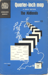
The maps were initially available sporting blue covers in a style otherwise similar to the One Inch range. However, in 1965 a more 'modern' design was produced, with the GB outline in white on a blue background, and then a series of black and white alternating boxes eminating from Caithness to show the 'area covered' map.
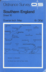
Finally, in 1970 a blue variant of the standard OS cover of the time was introduced.
- OS Quarter Inch covers
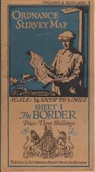
Third Series, from 1920s and 1930s
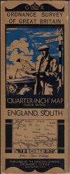
Pre-war Fourth Series
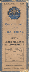
Post-war Fourth Series
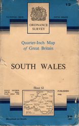
1950s/early 1960s Fifth Series
1965-70 Fifth Series
1970-75 Fifth Series

| OS Quarter Inch | ||||||||
| ||||||||
| ||||||||
|
.png)
.png)
