OS Pathfinder
| Pathfinder 1:25,000 | |||
 | |||
| |||
| Publisher: | Ordnance Survey | ||
| Scale: | 1:25,000 | ||
| First Published: | 1945 | ||
| Final Publication: | 1997 | ||
| SABRE Maps layer: | Yes | ||
The OS Pathfinder and 1:25,000 maps series was the first metric scale mapping produced by the Ordnance Survey. It was originally simply the 1:25,000 Series although for a short period of time in the 1960s 2½ inch map was used on the covers. These maps covered a single 10km OSGB National Grid square. The later Second Edition was a larger sheet covering two 10km grid squares per map, and was given the Pathfinder name (in a similar fashion to the 1:50,000 Series being renamed Landranger) in 1979.
It has now been replaced by the Explorer series of mapping at the same scale.
Provisional Edition
The initial 1:25,000 series mapping was produced in 1945 and was called the Provisional Edition. It was only ever intended, as the name suggests, as a temporary measure and was produced by redrawing pre-war mapping (sometimes from as far back as the 1920s), and then including major changes. The area covered by each map was very small (10km by 10km in most sheets) as well as being outdated when it was printed, and so the mapping was not particularly popular.
Due to the small size of the mapping, there were 2,027 sheets that covered most of Great Britain, though no sheets were produced that covered most of the Scottish Highlands or Islands. The series was completed in late 1956, although Provisional Edition sheets were still being produced (although ridiculously outdated) in the 1980s. Sheet SP22 Adlestrop has the distinction of being the least updated of all the sheets, with the 1951 map still on sale in 1983.
Despite the scale, road numbers barely appeared on Provisional Edition mapping.
Regular Edition
The Regular Edition was the intended replacement for the Provisional Edition, but for various reasons it never really got going. The poor sales of the Provisional Edition didn't exactly encourage the Ordnance Survey to hurry along the new sheets, and it took until 1956 for the first Regular Edition sheets to be produced.
Indeed, by 1962 the OS had already decided to replace the Regular Edition with a new series, so most mapping of the era was still Provisional Edition.
Again, road numbers were included in a hit-and-miss fashion.
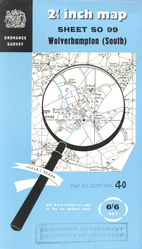
First Series
The First Series wasn't the replacement for the Regular Edition, as might be expected. Instead it was simply a 1970 rebrand of the previous Provisional and Regular Editions whilst the all-new Second Edition was being prepared.
The final fully redrawn First Series sheet, NS27 Greenock was produced in 1970. However further revisions continued on some sheets until the mid 1980s. A major drawback of all revised versions of this mapping was that revisions tended to be selective: roads were the usual main focus of revision, but frequently new buildings were not added. Hence the 1972 revision of NS66 Glasgow (East) shows the newly-constructed M73 but not the postwar housing scheme of Easterhouse which lies to the west of it. In some cases, as with the 1982 revision of SU65 Basingstoke, large areas of what had been open countryside are simply marked "building development".
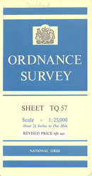
Second Series
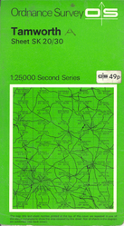
In 1965 the first Second Series sheets were published. These sheets covered a larger area than their predecessors (20km x 10km) and were more explicitly targeted at the tourist market, including places of interest and attractions. Replacement of the First Series by these sheets was gradual, and many early sheets covered the areas of the north and west of Scotland which had not yet been mapped. The series was renamed Pathfinder in 1980, and coverage of the whole of Great Britain was completed in 1989. However by then many of these sheets had already been replaced by the larger Outdoor Leisure series, itself a precursor of the Explorer series which would eventually replace Pathfinders by 2002.
As a result of their rapid withdrawal, several Pathfinders exist only in one state with no revisions, highly unusual for a GB-wide mapping series at this scale. Typical is the sheet which finally completed coverage of GB at 1:25,000: NR 63/73/83 Saddell and Carradale. Published once in November 1989, it was never revised before its 2001 replacement by an Explorer sheet.
SABRE Maps coverage
Full Coverage from the Provisional Edition is available on SABRE Maps, though as mentioned above it does not cover large parts of Scotland.
- OS Pathfinder and 1:25,000 covers
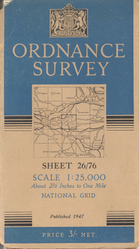
1947 cover
1960 cover
1961 cover
1971 Second Series cover
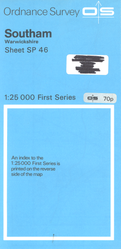
1972 First Series cover
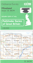
1980 Pathfinder cover
1989 Pathfinder cover


| OS Pathfinder | ||||||||
| ||||||||
|

